


Mapping Europe Checklist
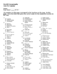
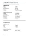
Instructions for drawing and coloring a map of Europe. Includes a list of the countries, independent states, capital cities, physical features, rivers and bodies of water that are to be located on the map.
Instructions for drawing and coloring a map of Europe. Includes a list of the countries, independent states, capital cities, physical features, rivers and bodies of water that are to be located on the map.
Leave a Reply